Grönviksvägen 124167 76 BrommaSweden, שוודיה
תנאי המכירה
הדגמת מכירה
המכירה הסתיימה
|
פריט 9:
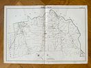
G.W. Bromley - Somerton Map, Byberry map - City of Philadelphia atlas map, Northeast - antique hand colored - 1910
עוד...
|
|


|
מחיר פתיחה:
300
Skr
הערכה :
2,000 Skr - 3,000 Skr
עמלת בית המכירות: 25%
|
G.W. Bromley - Somerton Map, Byberry map - City of Philadelphia atlas map, Northeast - antique hand colored - 1910
Somerton and Byberry Map, an original 1910 City of Philadelphia atlas map depicting Wards 35 and 41 in Northeast Philadelphia. The map details roads, property divisions, and landowners, illustrating the rural and suburban landscape of the area during the early 20th century. Key locations include Somerton, Byberry, Mechanicsville, and the surrounding farmland, with boundaries extending into Bucks County.This map is part of a 1910 Philadelphia atlas, likely produced by a well-known cartographic publisher such as G.W. Bromley or another atlas company documenting the city's development.Artist or Maker:G.W. BromleyMedium:hand coloredDate:1910
