Fine Art: Antique Prints, Maps, and Drawings
Por Dahlströms Fine Art
Contactar a la casa de subasta
22.3.25
Grönviksvägen 124167 76 BrommaSweden, Suecia
Términos y condiciones de venta
Ver demostración
La subasta ha concluído
|
LOTE 35:
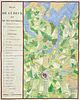
Ambroise Tardieu - Germany - Hand-coloured map of Lubeck and its surroundings - Plan de Lubeck et de ses environs / ...
más...
|
|


|
Precio inicial:
300
Skr
Precio estimado :
2 000 Skr - 3 000 Skr
Comisión de la casa de subasta: 25%
|
Ambroise Tardieu - Germany - Hand-coloured map of Lubeck and its surroundings - Plan de Lubeck et de ses environs / Part of a series of battle plans from the Napoleonic Wars - 1821-1850
This hand-coloured map of Lübeck and its surroundings in a copper engraving by Ambroise Tardieu from around 1830, part of a series of battle plans from the Napoleonic Wars. It depicts the city's urban and defensive state during the 1807 campaign. Title in the lower left corner, with a single linear scale. Above the upper frame, to the left, "Pl. 8," and to the right, "Campagne de 1807."
Ambroise Tardieu was a French cartographer and engraver active during the early 19th century. He was known for his detailed and precise maps as well as scientific illustrations. His works often appeared in atlases and geographical publications. Tardieu contributed significantly to the visual representation of geography and historical events.
Artist or Maker:
Ambroise Tardieu
Medium:
Copper engraving
Date:
1830
